Aerial Survey & Mapping Services
Get actionable data about your land with professional drone surveys. From wildlife population counts to crop health analysis, our aerial surveys deliver insights you can't get from the ground.
Why Choose Drone Surveys?
Aerial surveys cover more ground faster, with better accuracy and less disturbance than traditional methods.
100+ Acres/Hour
Cover large areas quickly with systematic flight patterns
High Accuracy
Thermal and multispectral sensors capture what eyes miss
Minimal Disturbance
Survey wildlife and crops without altering natural behavior
Actionable Reports
Professional deliverables you can use for decisions
Our Survey Services
Choose the survey type that fits your needs, or combine multiple surveys for comprehensive property intelligence.
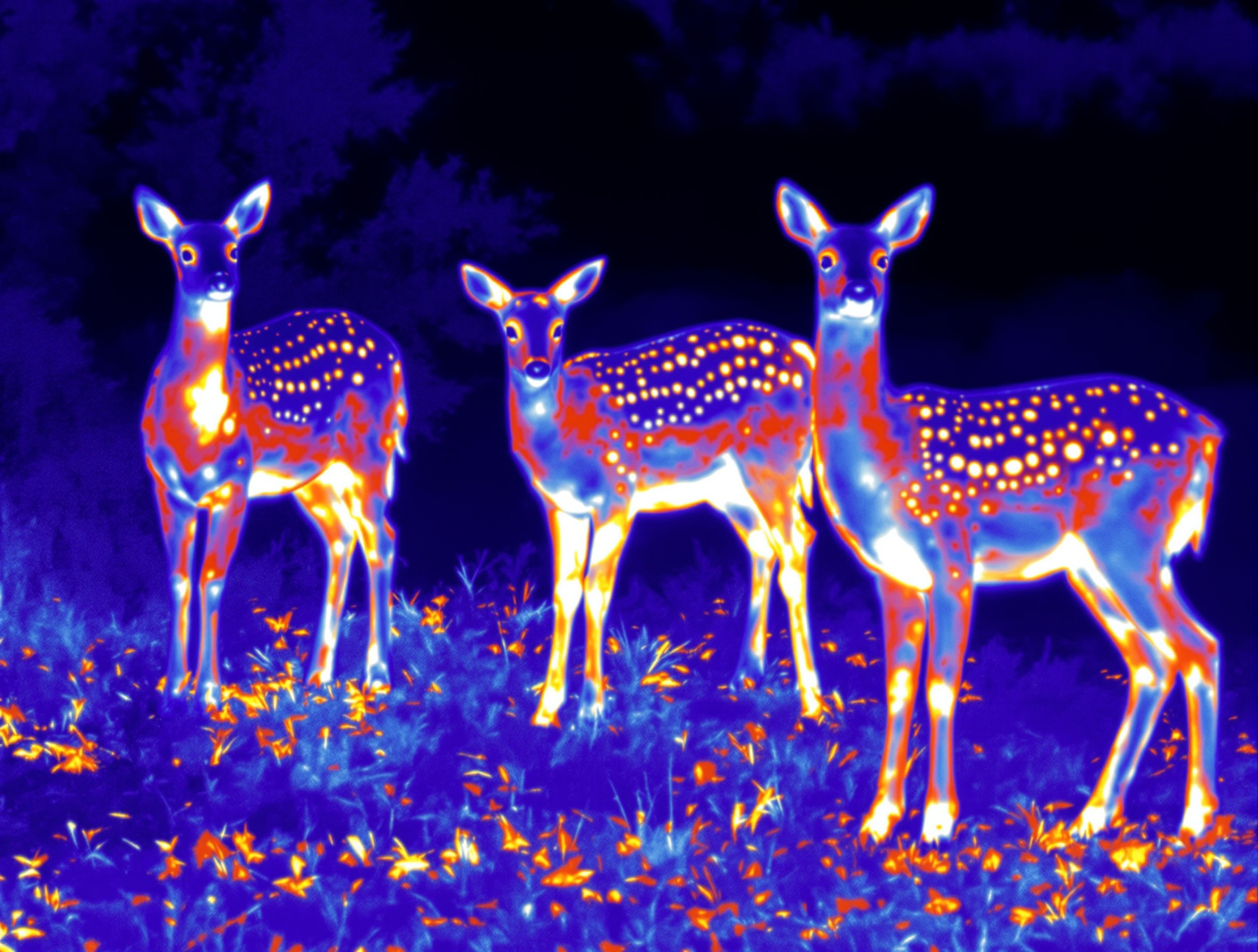
Deer Population Survey
Thermal imaging drone surveys provide accurate deer population estimates, movement patterns, and activity mapping. Make informed herd management decisions based on real data, not guesswork.
- Population density estimates by zone
- Movement corridors and bedding areas mapped
- Predator presence identification
- Professional summary report included
Crop Health Survey (RGB / NDVI)
See your fields the way they really are. Multispectral imaging reveals stand problems, emergence issues, stress patterns, and yield risk areas before they cost you bushels.
- Stand counts and emergence verification
- Early stress detection (nutrient, disease, water)
- Yield-risk zone mapping
- Drainage and compaction pattern identification
Property & Boundary Mapping
High-resolution aerial imagery for property documentation, boundary verification, and land planning. Perfect for real estate, land management, and development projects.
- High-resolution orthomosaic maps
- Fence line and boundary documentation
- Acreage verification and measurement
- Exportable files for GIS systems
Timber & Forestry Assessment
Aerial surveys for timber inventory, forest health assessment, and woodland management planning. Get comprehensive data on your forested acres without ground crews.
- Canopy health and density analysis
- Species identification and distribution
- Damage assessment (storm, disease, pest)
- Access road and trail mapping
Survey Pricing
Volume pricing means larger properties pay less per acre. All surveys include professional deliverables.
Bundle & Save
Combine multiple survey types in a single flight for maximum efficiency. When we're already flying your property, adding additional survey layers costs less than separate visits. Contact us for custom bundle pricing.
How It Works
From initial contact to final deliverables, we make the survey process simple and straightforward.
Request Quote
Tell us about your property and what you need surveyed. We'll provide pricing within 24 hours.
Schedule Flight
We coordinate timing based on weather, survey type, and your schedule. Most surveys completed within 1-2 weeks.
Survey Execution
Our trained operators fly systematic patterns to ensure complete coverage and accurate data capture.
Receive Report
Professional deliverables within 3-5 business days, including maps, analysis, and actionable insights.
Ready to Survey Your Property?
Get accurate data to support better land management decisions. Request a quote today and see what drone surveys can reveal about your property.